
Bagini Glacier Trek Overview
The Bagini Glacier is a stunning Himalayan glacier situated near the town of Joshimath in the Chamoli district of Uttarakhand, India. This trek is an ideal choice for those who enjoy challenging and adventurous treks.

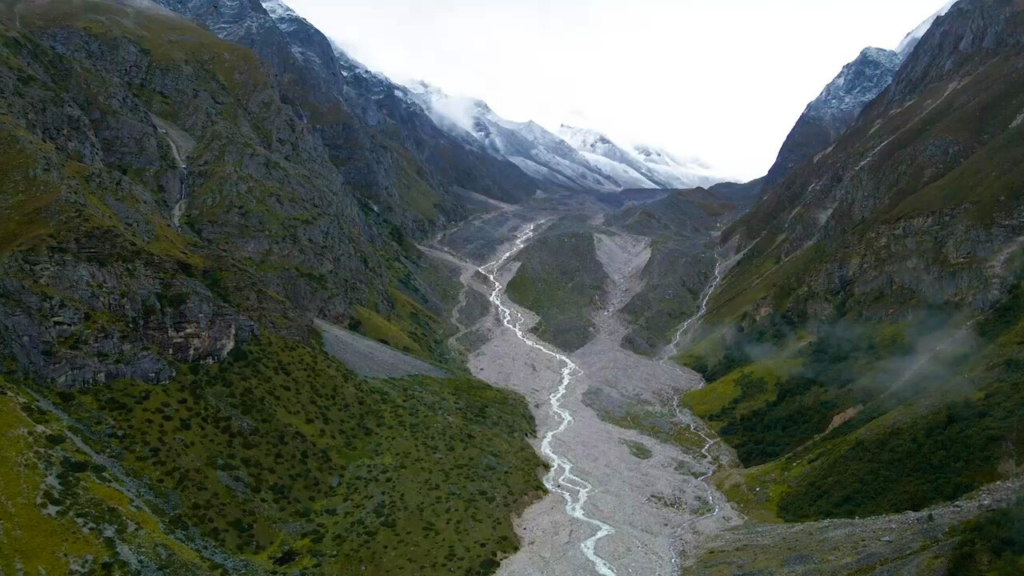
The trek commences from Joshimath and passes through Jumma and Ruing Village. The trail goes up and down through the forest, offering breathtaking views of Hathi Parvat, Ghori Parvat, and Bhumial God Temple. Dronagiri Village, which is both inhabited and in ruins, is a surprising sight. Continuing on from Dronagiri Village, you’ll reach the Bagini Base Camp, which offers magnificent views of the peaks, meadows, and landscapes. On the way to the base camp, you’ll be able to see the highly acclaimed Rishi Peak. The Bagini Nala is crossed by a sturdy bridge, and the path through the rocky and boulder-strewn terrain is both challenging and rewarding. Longatulli is another stop along the way, where you can marvel at the stunning views of Satminal, Hardeul, and Rishi Pahar.

History about Bagini Glacier & Changabang B.C route
Bagini Glacier is located in the Chamoli district of Uttarakhand in India. This location is highly sought-after by hikers and climbers due to its picturesque landscape and difficult topography. The glacier is situated at an altitude of 4,100 meters above sea level and is approximately 10 kilometers long.
The Changabang Base Camp (BC) route is a popular trekking and mountaineering route that leads to the base camp of Changabang peak, which is located near the Bagini Glacier. Changabang is a 6,864-meter high mountain peak in the Garhwal Himalayas, and is considered to be one of the most difficult peaks to climb in the world.
The history of Bagini Glacier and the Changabang BC route dates back to the early 20th century, when mountaineers began exploring the Himalayan region. In 1936, a British expedition led by Frank Smythe attempted to climb Changabang peak, but had to abandon their attempt due to bad weather conditions.
In 1951, another British expedition led by Eric Shipton attempted to climb Changabang peak, but also failed due to bad weather. However, the team was able to make the first ascent of a nearby peak called Mukut Parbat, which is located near the Bagini Glacier.
In 1974, a joint Indo-Japanese expedition successfully climbed Changabang peak via the North Face, which is considered to be the most difficult route to the summit. Since then, the Changabang BC route has become a popular destination among mountaineers from around the world.
In recent years, Bagini Glacier and the Changabang BC route have become more accessible to trekkers and mountaineers due to improvements in transportation and infrastructure in the region. However, the area is still considered to be a challenging and remote destination, and requires experienced guides and proper equipment to navigate safely.

Itinerary for Bagini Glacier Trek ( Route Map)
Day 1: Arrival in Joshimath
You can stay in Joshimath, a small town in the Chamoli district of Uttarakhand, and spend the night there.
Day 2: Joshimath to Jumma (45 km drive) and trek to Ruing village (2,800m)
After breakfast, you can drive to Jumma, which is the starting point of the trek. From Jumma, you will trek to Ruing village, which is situated at an altitude of 2,800m. The trek is about 6 km long and will take around 4-5 hours.
Day 3: Ruing Village to Dronagiri Village (3,200m)
You will trek to Dronagiri Village, which is located at an altitude of 3,200m. The trek is about 10 km long and will take around 6-7 hours.
Day 4: Dronagiri Village to Bagini Base Camp (3,700m)
Today, you will trek to Bagini Base Camp, which is located at an altitude of 3,700m. The trek is about 8 km long and will take around 6-7 hours.
Day 5: Bagini Base Camp to Bagini Glacier (4,100m) and back to Base Camp
Today, you will trek to Bagini Glacier, which is located at an altitude of 4,100m. You will spend some time exploring the glacier and then return to the Base Camp. The trek is about 8 km long and will take around 6-7 hours.
Day 6: Bagini Base Camp to Ruing Village
You will trek back to Ruing Village, which is situated at an altitude of 2,800m. The trek is about 18 km long and will take around 8-9 hours
Day 7: Ruing Village to Jumma and drive to Joshimath
Today, you will trek back to Jumma and then drive back to Joshimath. You will spend the night in Joshimath.
Note: This itinerary is just a suggested one, and it may vary depending on the tour operator, weather conditions, and the physical fitness of the trekker.
Bagini glacier trek difficulty level
The Bagini Glacier Trek is graded as moderate to difficult due to the narrow trails, rocks, and boulders along the route. This may prove challenging for beginners, and it requires a high level of concentration to navigate safely. With a maximum altitude of 14,816 feet, it is essential to maintain physical fitness through regular exercise and healthy eating to avoid over-exhaustion during the trek.
Is Bagini Glacier trek safe?
It is natural to feel anxious before embarking on your first trek. The Bagini Glacier Trek is graded as moderate, so while the trail may have its challenges, it is not excessively risky. It is still recommended to assess your physical fitness level before signing up for the trek. Maintaining focus and attentiveness during the trek is important for safety. Additionally, Moxtain Pvt. Ltd. prioritizes the safety of its trekkers and provides professional guidance and supervision throughout the journey.